
2 photos
@quadrant-D8-ysla-degvajan

Seems you enter wrong password click here to enter password again.
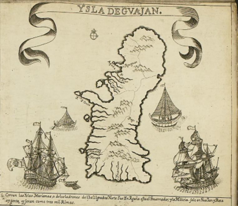
The Quadrant D8 of the Murillo Velarde 1734 map, which features "Ysla de Guajan" (Island of Guam).
1. Island Depiction
The map illustrates Guam, the largest island in the Mariana Islands.
It is shown with mountain ranges, rivers, and coastal settlements.
Spanish annotations label key locations.
Maritime Elements
Galleons & Native Boats
The quadrant includes Spanish galleons and local Chamorro canoes, signifying the maritime activity in the region.
This highlights Guam’s role as a key stopover for the Manila-Acapulco Galleon Trade.
Compass Rose & Navigation Marks
Helps Spanish navigators chart courses through the Pacific.
Historical Context
Spanish Colonization
Guam was a vital resupply point for Spanish ships crossing the Pacific.
The island was administered from Manila, reinforcing the Philippines' importance in Spain’s Pacific empire.
Chamorro Population
The text mentions a population estimate of around 3,000 people.
The native Chamorro people were influenced by Spanish missions and governance.
Strategic Importance
Guam served as a Spanish military outpost against pirate raids and foreign incursions.
The island was a key link between the Philippines and New Spain (Mexico).
Significance of This Quadrant
Highlights Guam’s role in the Spanish Empire and its connection to the Philippines.
Illustrates early Chamorro culture and Spanish influences.
Provides insight into Spanish maritime routes in the Pacific.
Ysla Degvajan

Mapping the Future of Collective Human Dignity